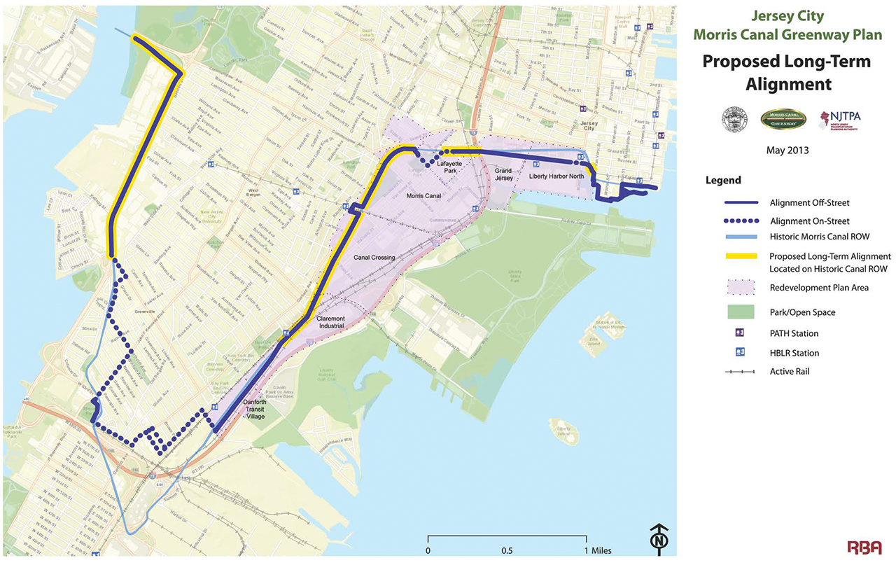
In February, Jersey Digs reported on plans to develop a continuous 102-mile Morris Canal Greenway for pedestrians and bicyclists that would stretch from the Delaware River in Phillipsburg to the Hudson River in Jersey City. Now, steps are being taken by local officials in two Hudson County municipalities in order to make the project a reality.
According to records from the Jersey City Redevelopment Agency (JCRA), its Board of Commissioners voted on October 17 to enter into a purchase and sale agreement in order to acquire several properties within Jersey City’s municipal limits from the city of Bayonne “for the development of a portion of the Morris Canal Greenway.” The resolution goes on to state that Jersey City would maintain its new portion of the greenway, and that the sale would benefit residents of Bayonne and Jersey City who would utilize it once completed. However, the newly acquired lands would replace existing parkland on the Jersey City Recreation and Open Space Inventory, according to the documents.
The properties in question include large vertical tracts in Ward A that have been mostly vacant since the canal closed. They stretch south from the corner of Route 440 and Danforth Avenue near Wonder Bagels all the way to West 63rd Street near the southern portion of McGovern Park.
[gmap height=”250px”]431 Danforth Avenue, Jersey City, NJ[/gmap]
(Map of the area where Bayonne is selling property to Jersey City. Wonder Bagels is the marker)
The city of Bayonne and its Municipal Utilities Authority owns these properties because the municipality’s sewage treatment pipeline operates underground beneath them. State records show that the pipeline travels through this part of Jersey City as well as portions of Kearny, since it connects a pumping station on Oak Street in Bayonne with the Passaic Valley Sewerage Commission’s Water Pollution Control Facility in Newark’s East Ward.
According to the City of Jersey City’s Morris Canal Greenway Plan, which was released in 2013, the canal traveled south through Jersey City before reaching an area called Fiddler’s Elbow and turning northeast towards Bergen-Lafayette and the Hudson River. When completed, 41 percent of this the 8.5-mile trail in Jersey City is expected to be on the actual canal path, while the remaining parts will be a mixture of on-street and off-street pathways.
The statewide trail, which would pass through six counties, will be developed along the route of the historic canal, which opened in the mid-1830s in order to transport anthracite coal from the northeastern Pennsylvania mountains to the New York metropolitan area.
A trip from Jersey City through the Watchung Mountains and other areas with hilly terrain to Phillipsburg along Route 78 can now be made in a little over an hour. One hundred forty years ago, transporting items between the two communities along the Morris Canal took five days or more. The ability to transport items for such a far distance and through high elevations forever transformed the landscape of the state.
Today, although there are a handful of municipalities with parks and trails to commemorate the canal, few traces of it are easy to find. Parts of the historic canal might actually remain below Jersey City’s Ward A. A city report states that “the below-ground condition of the canal is not known, although its main channel may remain intact and be filled with mid-20th-century debris.” However, because of the lack of visible above-ground signs of the Morris Canal, historians and officials are looking to make members of the public more aware of this aspect of New Jersey’s transportation heritage through projects such as the Morris Canal Greenway.


